Throwback Thursday: Apollo 11 FAQ Edition
Throwback Thursday: Apollo 11 FAQ Edition

With the help of the NASA History Office, we’ve identified some of the most frequently asked questions surrounding the first time humans walked on the surface of another world. Read on and click here to check out our previous Apollo FAQs.
How many moon rocks did the Apollo crews bring back? What did we learn?

The six crews that landed on the Moon brought back 842 pounds (382 kilograms) of rocks, sand and dust from the lunar surface. Each time, they were transferred to Johnson Space Center’s Lunar Receiving Laboratory, a building that also housed the astronauts during their three weeks of quarantine. Today the building now houses other science divisions, but the lunar samples are preserved in the Lunar Sample Receiving Laboratory.
Built in 1979, the laboratory is the chief repository of the Apollo samples.

From these pieces of the Moon we learned that its chemical makeup is similar to that of Earth’s, with some differences. Studying the samples has yielded clues to the origins of the solar system. In March of 2019, we announced that three cases of pristine Moon samples will be unsealed for the first time in 50 years so that we can take advantage of the improved technology that exists today!
Did you know you might not have to travel far to see a piece of the Moon up close? Visit our Find a Moon Rock page to find out where you can visit a piece of the Moon.
What did Apollo astronauts eat on their way to the Moon?

Astronaut food has come a long way since the days of Project Mercury, our first human spaceflight program that ran from 1958-1963. Back then, astronauts “enjoyed” food in cube form or squeezed out of tubes. Early astronaut food menus were designed less for flavor and more for nutritional value, but that eventually shifted as technology evolved. Astronauts today can enjoy whole foods like apples, pizza and even tacos.
Apollo crews were the first to have hot water, making it easier to rehydrate their foods and improve its taste. They were also the first to use a “spoon bowl,” a plastic container that was somewhat like eating out of a Ziploc bag with a spoon. Here’s an example of a day’s menu for a voyage to the Moon:
Breakfast: bacon squares, strawberry cubes and an orange drink.
Lunch: beef and potatoes, applesauce and a brownie.
Dinner: salmon salad, chicken and rice, sugar cookie cubes and a pineapple grapefruit drink.
What did Michael Collins do while he orbited the Moon, alone in the Command Module?

As Neil Armstrong and Buzz Aldrin worked on the lunar surface, Command Module pilot Michael Collins orbited the Moon, alone, for the next 21.5 hours. On board he ran systems checks, made surface observations and communicated with Mission Control when there wasn’t a communications blackout. Blackouts happened every time Collins went behind the Moon. In 2009, Collins wrote this in response to a flurry of media questions about the 40th anniversary of the mission:
Q. Circling the lonely Moon by yourself, the loneliest person in the universe, weren’t you lonely? A. No. Far from feeling lonely or abandoned, I feel very much a part of what is taking place on the lunar surface. I know that I would be a liar or a fool if I said that I have the best of the three Apollo 11 seats, but I can say with truth and equanimity that I am perfectly satisfied with the one I have. This venture has been structured for three men, and I consider my third to be as necessary as either of the other two.”
What will Artemis astronauts bring back when they land on the Moon?

Artemis missions to the Moon will mark humanity’s first permanent presence on another world. The first woman and the next man to explore the lunar surface will land where nobody has ever attempted to land before – on the Moon’s south pole where there are billions of tons of water ice that can be used for oxygen and fuel. We don’t know yet what astronauts will bring back from this unexplored territory, but we do know that they will return with hope and inspiration for the next generation of explorers: the Artemis generation. Make sure to follow us on Tumblr for your regular dose of space: http://nasa.tumblr.com.
More Posts from Ocrim1967 and Others
Extreme Science: Launching Sounding Rockets from The Arctic
This winter, our scientists and engineers traveled to the world’s northernmost civilian town to launch rockets equipped with cutting-edge scientific instruments.

This is the beginning of a 14-month-long campaign to study a particular region of Earth’s magnetic field — which means launching near the poles. What’s it like to launch a science rocket in these extreme conditions?

Our planet is protected by a natural magnetic field that deflects most of the particles that flow out from the Sun — the solar wind — away from our atmosphere. But near the north and south poles, two oddities in Earth’s magnetic field funnel these solar particles directly into our atmosphere. These regions are the polar cusps, and it turns out they’re the ideal spot for studying how our atmosphere interacts with space.

The scientists of the Grand Challenge Initiative — Cusp are using sounding rockets to do their research. Sounding rockets are suborbital rockets that launch to a few hundred miles in altitude, spending a few minutes in space before falling back to Earth. That means sounding rockets can carry sensitive instruments above our atmosphere to study the Sun, other stars and even distant galaxies.
They also fly directly through some of the most interesting regions of Earth’s atmosphere, and that’s what scientists are taking advantage of for their Grand Challenge experiments.

One of the ideal rocket ranges for cusp science is in Ny-Ålesund, Svalbard, off the coast of Norway and within the Arctic circle. Because of its far northward position, each morning Svalbard passes directly under Earth’s magnetic cusp.
But launching in this extreme, remote environment puts another set of challenges on the mission teams. These launches need to happen during the winter, when Svalbard experiences 24/7 darkness because of Earth’s axial tilt. The launch teams can go months without seeing the Sun.

Like for all rocket launches, the science teams have to wait for the right weather conditions to launch. Because they’re studying upper atmospheric processes, some of these teams also have to wait for other science conditions, like active auroras. Auroras are created when charged particles collide with Earth’s atmosphere — often triggered by solar storms or changes in the solar wind — and they’re related to many of the upper-atmospheric processes that scientists want to study near the magnetic cusp.

But even before launch, the extreme conditions make launching rockets a tricky business — it’s so cold that the rockets must be encased in styrofoam before launch to protect them from the low temperatures and potential precipitation.

When all is finally ready, an alarm sounds throughout the town of Ny-Ålesund to alert residents to the impending launch. And then it’s up, up and away! This photo shows the launch of the twin VISIONS-2 sounding rockets on Dec. 7, 2018 from Ny-Ålesund.

These rockets are designed to break up during flight — so after launch comes clean-up. The launch teams track where debris lands so that they can retrieve the pieces later.

The next launch of the Grand Challenge Initiative is AZURE, launching from Andøya Space Center in Norway in April 2019.
For even more about what it’s like to launch science rockets in extreme conditions, check out one scientist’s notes from the field: https://go.nasa.gov/2QzyjR4

For updates on the Grand Challenge Initiative and other sounding rocket flights, visit nasa.gov/soundingrockets or follow along with NASA Wallops and NASA heliophysics on Twitter and Facebook.
@NASA_Wallops | NASA’s Wallops Flight Facility | @NASASun | NASA Sun Science
All cats are beautiful 🐱❤️


Hurricanes Have No Place to Hide, Thanks to Better Satellite Forecasts

If you’ve ever looked at a hurricane forecast, you’re probably familiar with “cones of uncertainty,” the funnel-shaped maps showing a hurricane’s predicted path. Thirty years ago, a hurricane forecast five days before it made landfall might have a cone of uncertainty covering most of the East Coast. The result? A great deal of uncertainty about who should evacuate, where it was safe to go, and where to station emergency responders and their equipment.

Over the years, hurricane forecasters have succeeded in shrinking the cone of uncertainty for hurricane tracks, with the help of data from satellites. Polar-orbiting satellites, which fly nearly directly above the North and South Poles, are especially important in helping cut down on forecast error.

The orbiting electronic eyeballs key to these improvements: the Joint Polar Satellite System (JPSS) fleet. A collaborative effort between NOAA and NASA, the satellites circle Earth, taking crucial measurements that inform the global, regional and specialized forecast models that have been so critical to hurricane track forecasts.

The forecast successes keep rolling in. From Hurricanes Harvey, Irma and Maria in 2017 through Hurricanes Florence and Michael in 2018, improved forecasts helped manage coastlines, which translated into countless lives and property saved. In September 2018, with the help of this data, forecasters knew a week ahead of time where and when Hurricane Florence would hit. Early warnings were precise enough that emergency planners could order evacuations in time — with minimal road clogging. The evacuations that did not have to take place, where residents remained safe from the hurricane’s fury, were equally valuable.

The satellite benefits come even after the storms make landfall. Using satellite data, scientists and forecasters monitor flooding and even power outages. Satellite imagery helped track power outages in Puerto Rico after Hurricane Maria and in the Key West area after Hurricane Irma, which gave relief workers information about where the power grid was restored – and which regions still lacked electricity.

Flood maps showed the huge extent of flooding from Hurricane Harvey and were used for weeks after the storm to monitor changes and speed up recovery decisions and the deployment of aid and relief teams.

As the 2019 Atlantic hurricane season kicks off, the JPSS satellites, NOAA-20 and Suomi-NPP, are ready to track hurricanes and tropical cyclones as they form, intensify and travel across the ocean – our eyes in the sky for severe storms.
For more about JPSS, follow @JPSSProgram on Twitter and facebook.com/JPSS.Program, or @NOAASatellites on Twitter and facebook.com/NOAASatellites.
Make sure to follow us on Tumblr for your regular dose of space: http://nasa.tumblr.com.
Frozen: Ice on Earth and Well Beyond

Icy Hearts: A heart-shaped calving front of a glacier in Greenland (left) and Pluto’s frozen plains (right). Credits: NASA/Maria-Jose Viñas and NASA/APL/SwRI
From deep below the soil at Earth’s polar regions to Pluto’s frozen heart, ice exists all over the solar system…and beyond. From right here on our home planet to moons and planets millions of miles away, we’re exploring ice and watching how it changes. Here’s 10 things to know:
1. Earth’s Changing Ice Sheets

An Antarctic ice sheet. Credit: NASA
Ice sheets are massive expanses of ice that stay frozen from year to year and cover more than 6 million square miles. On Earth, ice sheets extend across most of Greenland and Antarctica. These two ice sheets contain more than 99 percent of the planet’s freshwater ice. However, our ice sheets are sensitive to the changing climate.
Data from our GRACE satellites show that the land ice sheets in both Antarctica and Greenland have been losing mass since at least 2002, and the speed at which they’re losing mass is accelerating.
2. Sea Ice at Earth’s Poles

Earth’s polar oceans are covered by stretches of ice that freezes and melts with the seasons and moves with the wind and ocean currents. During the autumn and winter, the sea ice grows until it reaches an annual maximum extent, and then melts back to an annual minimum at the end of summer. Sea ice plays a crucial role in regulating climate – it’s much more reflective than the dark ocean water, reflecting up to 70 percent of sunlight back into space; in contrast, the ocean reflects only about 7 percent of the sunlight that reaches it. Sea ice also acts like an insulating blanket on top of the polar oceans, keeping the polar wintertime oceans warm and the atmosphere cool.
Some Arctic sea ice has survived multiple years of summer melt, but our research indicates there’s less and less of this older ice each year. The maximum and minimum extents are shrinking, too. Summertime sea ice in the Arctic Ocean now routinely covers about 30-40 percent less area than it did in the late 1970s, when near-continuous satellite observations began. These changes in sea ice conditions enhance the rate of warming in the Arctic, already in progress as more sunlight is absorbed by the ocean and more heat is put into the atmosphere from the ocean, all of which may ultimately affect global weather patterns.
3. Snow Cover on Earth

Snow extends the cryosphere from the poles and into more temperate regions.
Snow and ice cover most of Earth’s polar regions throughout the year, but the coverage at lower latitudes depends on the season and elevation. High-elevation landscapes such as the Tibetan Plateau and the Andes and Rocky Mountains maintain some snow cover almost year-round. In the Northern Hemisphere, snow cover is more variable and extensive than in the Southern Hemisphere.
Snow cover the most reflective surface on Earth and works like sea ice to help cool our climate. As it melts with the seasons, it provides drinking water to communities around the planet.
4. Permafrost on Earth

Tundra polygons on Alaska’s North Slope. As permafrost thaws, this area is likely to be a source of atmospheric carbon before 2100. Credit: NASA/JPL-Caltech/Charles Miller
Permafrost is soil that stays frozen solid for at least two years in a row. It occurs in the Arctic, Antarctic and high in the mountains, even in some tropical latitudes. The Arctic’s frozen layer of soil can extend more than 200 feet below the surface. It acts like cold storage for dead organic matter – plants and animals.
In parts of the Arctic, permafrost is thawing, which makes the ground wobbly and unstable and can also release those organic materials from their icy storage. As the permafrost thaws, tiny microbes in the soil wake back up and begin digesting these newly accessible organic materials, releasing carbon dioxide and methane, two greenhouse gases, into the atmosphere.
Two campaigns, CARVE and ABoVE, study Arctic permafrost and its potential effects on the climate as it thaws.
5. Glaciers on the Move

Did you know glaciers are constantly moving? The masses of ice act like slow-motion rivers, flowing under their own weight. Glaciers are formed by falling snow that accumulates over time and the slow, steady creep of flowing ice. About 10 percent of land area on Earth is covered with glacial ice, in Greenland, Antarctica and high in mountain ranges; glaciers store much of the world’s freshwater.
Our satellites and airplanes have a bird’s eye view of these glaciers and have watched the ice thin and their flows accelerate, dumping more freshwater ice into the ocean, raising sea level.
6. Pluto’s Icy Heart

The nitrogen ice glaciers on Pluto appear to carry an intriguing cargo: numerous, isolated hills that may be fragments of water ice from Pluto’s surrounding uplands. NASA/Johns Hopkins University Applied Physics Laboratory/Southwest Research Institute
Pluto’s most famous feature – that heart! – is stone cold. First spotted by our New Horizons spacecraft in 2015, the heart’s western lobe, officially named Sputnik Planitia, is a deep basin containing three kinds of ices – frozen nitrogen, methane and carbon monoxide.
Models of Pluto’s temperatures show that, due the dwarf planet’s extreme tilt (119 degrees compared to Earth’s 23 degrees), over the course of its 248-year orbit, the latitudes near 30 degrees north and south are the coldest places – far colder than the poles. Ice would have naturally formed around these latitudes, including at the center of Sputnik Planitia.
New Horizons also saw strange ice formations resembling giant knife blades. This “bladed terrain” contains structures as tall as skyscrapers and made almost entirely of methane ice, likely formed as erosion wore away their surfaces, leaving dramatic crests and sharp divides. Similar structures can be found in high-altitude snowfields along Earth’s equator, though on a very different scale.
7. Polar Ice on Mars

This image, combining data from two instruments aboard our Mars Global Surveyor, depicts an orbital view of the north polar region of Mars. Credit: NASA/JPL-Caltech/MSSS
Mars has bright polar caps of ice easily visible from telescopes on Earth. A seasonal cover of carbon dioxide ice and snow advances and retreats over the poles during the Martian year, much like snow cover on Earth.

This animation shows a side-by-side comparison of CO2 ice at the north (left) and south (right) Martian poles over the course of a typical year (two Earth years). This simulation isn’t based on photos; instead, the data used to create it came from two infrared instruments capable of studying the poles even when they’re in complete darkness. This data were collected by our Mars Reconnaissance Orbiter, and Mars Global Surveyor. Credit: NASA/JPL-Caltech
During summertime in the planet’s north, the remaining northern polar cap is all water ice; the southern cap is water ice as well, but remains covered by a relatively thin layer of carbon dioxide ice even in summertime.
Scientists using radar data from our Mars Reconnaissance Orbiter found a record of the most recent Martian ice age in the planet’s north polar ice cap. Research indicates a glacial period ended there about 400,000 years ago. Understanding seasonal ice behavior on Mars helps scientists refine models of the Red Planet’s past and future climate.
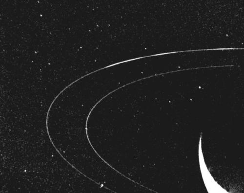
8. Ice Feeds a Ring of Saturn

Wispy fingers of bright, icy material reach tens of thousands of kilometers outward from Saturn’s moon Enceladus into the E ring, while the moon’s active south polar jets continue to fire away. Credit: NASA/JPL/Space Science Institute
Saturn’s rings and many of its moons are composed of mostly water ice – and one of its moons is actually creating a ring. Enceladus, an icy Saturnian moon, is covered in “tiger stripes.” These long cracks at Enceladus’ South Pole are venting its liquid ocean into space and creating a cloud of fine ice particles over the moon’s South Pole. Those particles, in turn, form Saturn’s E ring, which spans from about 75,000 miles (120,000 kilometers) to about 260,000 miles (420,000 kilometers) above Saturn’s equator. Our Cassini spacecraft discovered this venting process and took high-resolution images of the system.

Jets of icy particles burst from Saturn’s moon Enceladus in this brief movie sequence of four images taken on Nov. 27, 2005. Credit: NASA/JPL/Space Science Institute
9. Ice Rafts on Europa

View of a small region of the thin, disrupted, ice crust in the Conamara region of Jupiter’s moon Europa showing the interplay of surface color with ice structures. Credit: NASA/JPL/University of Arizona
The icy surface of Jupiter’s moon Europa is crisscrossed by long fractures. During its flybys of Europa, our Galileo spacecraft observed icy domes and ridges, as well as disrupted terrain including crustal plates that are thought to have broken apart and “rafted” into new positions. An ocean with an estimated depth of 40 to 100 miles (60 to 150 kilometers) is believed to lie below that 10- to 15-mile-thick (15 to 25 km) shell of ice.
The rafts, strange pits and domes suggest that Europa’s surface ice could be slowly turning over due to heat from below. Our Europa Clipper mission, targeted to launch in 2022, will conduct detailed reconnaissance of Europa to see whether the icy moon could harbor conditions suitable for life.
10. Crater Ice on Our Moon

The image shows the distribution of surface ice at the Moon’s south pole (left) and north pole (right), detected by our Moon Mineralogy Mapper instrument. Credit: NASA
In the darkest and coldest parts of our Moon, scientists directly observed definitive evidence of water ice. These ice deposits are patchy and could be ancient. Most of the water ice lies inside the shadows of craters near the poles, where the warmest temperatures never reach above -250 degrees Fahrenheit. Because of the very small tilt of the Moon’s rotation axis, sunlight never reaches these regions.
A team of scientists used data from a our instrument on India’s Chandrayaan-1 spacecraft to identify specific signatures that definitively prove the water ice. The Moon Mineralogy Mapper not only picked up the reflective properties we’d expect from ice, but was able to directly measure the distinctive way its molecules absorb infrared light, so it can differentiate between liquid water or vapor and solid ice.
With enough ice sitting at the surface – within the top few millimeters – water would possibly be accessible as a resource for future expeditions to explore and even stay on the Moon, and potentially easier to access than the water detected beneath the Moon’s surface.
11. Bonus: Icy World Beyond Our Solar System!

With an estimated temperature of just 50K, OGLE-2005-BLG-390L b is the chilliest exoplanet yet discovered. Pictured here is an artist’s concept. Credit: NASA
OGLE-2005-BLG-390Lb, the icy exoplanet otherwise known as Hoth, orbits a star more than 20,000 light years away and close to the center of our Milky Way galaxy. It’s locked in the deepest of deep freezes, with a surface temperature estimated at minus 364 degrees Fahrenheit (minus 220 Celsius)!
Make sure to follow us on Tumblr for your regular dose of space: http://nasa.tumblr.com.


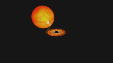

Millisecond Pulsar with Magnetic Field Structure
A pulsar is a rapidly rotating neutron star that emits pulses of radiation (such as X-rays and radio waves) at regular intervals. A millisecond pulsar is one with a rotational period between 1 and 10 milliseconds, or from 60,000 to 6,000 revolutions per minute. Pulsars form in supernova explosions, but even newborn pulsars don’t spin at millisecond speeds, and they gradually slow down with age. If, however, a pulsar is a member of a binary system with a normal star, gas transferred from the companion can spin up an old, slow pulsar to the millisecond range.
Credit: NASA, Dana Berry: Lead Animator Michael McClare (HTSI)


(Source)

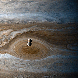
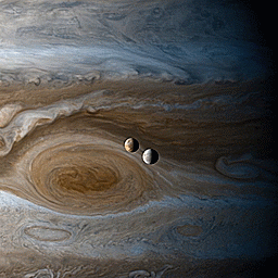
Created using still images taken by the Cassini spacecraft during it’s flyby of Jupiter and while at Saturn. Shown is Io and Europa over Jupiter’s Great Red Spot.
NASA/JPL-Caltech/SSI/CICLOPS/Kevin M. Gill
The Kepler space telescope has shown us our galaxy is teeming with planets — and other surprises

The Kepler space telescope has taught us there are so many planets out there, they outnumber even the stars. Here is a sample of these wondrous, weird and unexpected worlds (and other spectacular objects in space) that Kepler has spotted with its “eye” opened to the heavens.
Kepler has found that double sunsets really do exist.

Yes, Star Wars fans, the double sunset on Tatooine could really exist. Kepler discovered the first known planet around a double-star system, though Kepler-16b is probably a gas giant without a solid surface.
Kepler has gotten us closer to finding planets like Earth.

Nope. Kepler hasn’t found Earth 2.0, and that wasn’t the job it set out to do. But in its survey of hundreds of thousands of stars, Kepler found planets near in size to Earth orbiting at a distance where liquid water could pool on the surface. One of them, Kepler-62f, is about 40 percent bigger than Earth and is likely rocky. Is there life on any of them? We still have a lot more to learn.
This sizzling world is so hot iron would melt!

One of Kepler’s early discoveries was the small, scorched world of Kepler-10b. With a year that lasts less than an Earth day and density high enough to imply it’s probably made of iron and rock, this “lava world” gave us the first solid evidence of a rocky planet outside our solar system.
If it’s not an alien megastructure, what is this oddly fluctuating star?

When Kepler detected the oddly fluctuating light from “Tabby’s Star,” the internet lit up with speculation of an alien megastructure. Astronomers have concluded it’s probably an orbiting dust cloud.
Kepler caught this dead star cannibalizing its planet.

What happens when a solar system dies? Kepler discovered a white dwarf, the compact corpse of a star in the process of vaporizing a planet.
These Kepler planets are more than twice the age of our Sun!

The five small planets in Kepler-444 were born 11 billion years ago when our galaxy was in its youth. Imagine what these ancient planets look like after all that time?
Kepler found a supernova exploding at breakneck speed.

This premier planet hunter has also been watching stars explode. Kepler recorded a sped-up version of a supernova called a “fast-evolving luminescent transit” that reached its peak brightness at breakneck speed. It was caused by a star spewing out a dense shell of gas that lit up when hit with the shockwave from the blast.
* All images are artist illustrations.
Make sure to follow us on Tumblr for your regular dose of space: http://nasa.tumblr.com
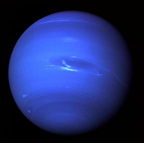
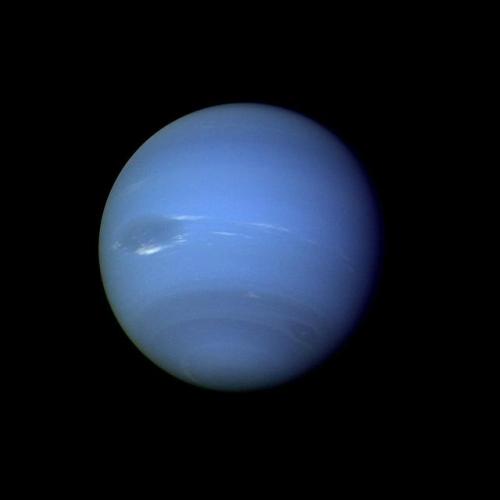
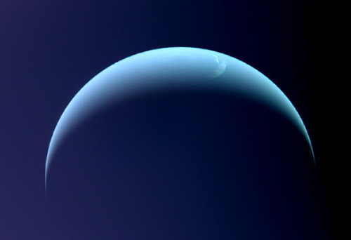
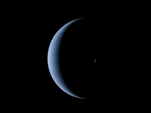
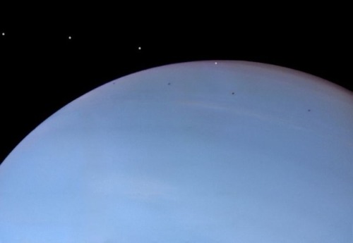
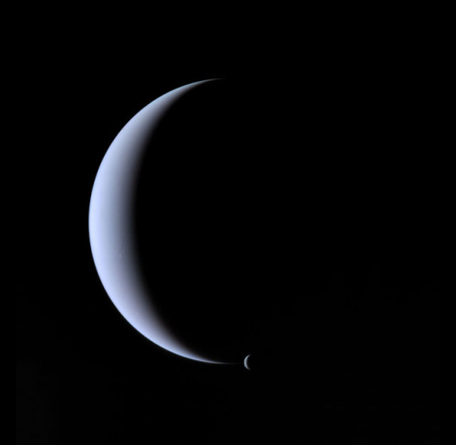
Neptune ♆
On this day in 1846 was discovered the planet Neptune.
The ice giant Neptune was the first planet located through mathematical predictions rather than through regular observations of the sky. (Galileo had recorded it as a fixed star during observations with his small telescope in 1612 and 1613.) When Uranus didn’t travel exactly as astronomers expected it to, a French mathematician, Urbain Joseph Le Verrier, proposed the position and mass of another as yet unknown planet that could cause the observed changes to Uranus’ orbit. After being ignored by French astronomers, Le Verrier sent his predictions to Johann Gottfried Galle at the Berlin Observatory, who found Neptune on his first night of searching in 1846. Seventeen days later, its largest moon, Triton, was also discovered.
Neptune is invisible to the naked eye because of its extreme distance from Earth. Interestingly, the highly eccentric orbit of the dwarf planet Pluto brings Pluto inside Neptune’s orbit for a 20-year period out of every 248 Earth years. Pluto can never crash into Neptune, though, because for every three laps Neptune takes around the Sun, Pluto makes two. This repeating pattern prevents close approaches of the two bodies.
Nearly 4.5 billion kilometers (2.8 billion miles) from the Sun, Neptune orbits the Sun once every 165 years.
Uranus’ blue-green color is also the result of atmospheric methane, but Neptune is a more vivid, brighter blue, so there must be an unknown component that causes the more intense color.
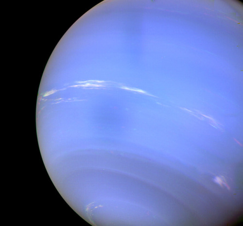
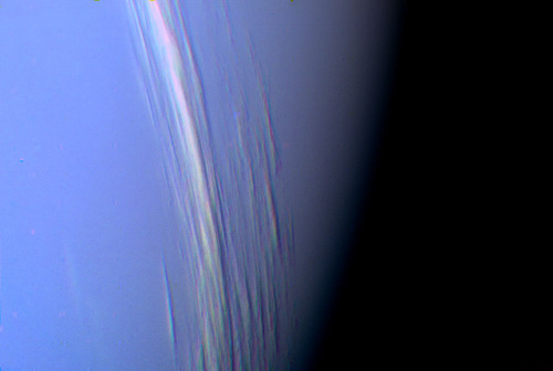
Despite its great distance and low energy input from the Sun, Neptune’s winds can be three times stronger than Jupiter’s and nine times stronger than Earth’s.
Winds on Neptune travel faster than the speed of sound.
In 1989, Voyager 2 tracked a large, oval-shaped, dark storm in Neptune’s southern hemisphere. This “Great Dark Spot” was large enough to contain the entire Earth.
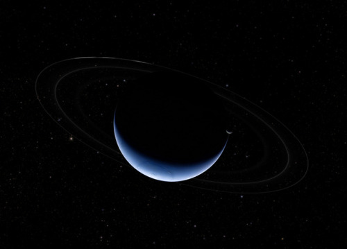
Neptune has five known rings. Voyager 2’s observations confirmed that these unusual rings are not uniform but have four thick regions (clumps of dust) called arcs. The rings are thought to be relatively young and short-lived.
Neptune has 14 known moons, six of which were discovered by Voyager 2.
Triton, Neptune’s largest moon, orbits the planet in the opposite direction compared with the rest of the moons, suggesting that it may have been captured by Neptune in the distant past.
To know more about the planet Neptune click here and here.
Images credit: NASA/JPL- Caltech (some images processed by Kevin M. Gill)
-
 takeagiantstep23 liked this · 11 months ago
 -
 gottalottarocks liked this · 1 year ago
 -
 superpixie reblogged this · 1 year ago
 -
 anisaanisa liked this · 1 year ago
 -
 nandalikesstuff reblogged this · 1 year ago
 -
anisaanisa reblogged this · 1 year ago
-
 tonguethulhu liked this · 3 years ago
 -
 peachy-keeyn reblogged this · 3 years ago
 -
 entropiccollapse liked this · 4 years ago
 -
 titania-harbinger liked this · 4 years ago
 -
 rustiancho liked this · 4 years ago
 -
 oshacertifiedforkliftoperator liked this · 4 years ago
 -
 maj0rmin3r1 liked this · 4 years ago
 -
 i-have-a-permit liked this · 4 years ago
 -
 kenny-wind-yt reblogged this · 4 years ago
 -
kenny-wind-yt liked this · 4 years ago
-
 cplus902 reblogged this · 4 years ago
 -
 may-fires reblogged this · 4 years ago
 -
 socialmediasocrates reblogged this · 4 years ago
 -
socialmediasocrates liked this · 4 years ago
-
 trashcat-waifu liked this · 4 years ago
 -
 agramoon liked this · 4 years ago
 -
 therandominternetperson liked this · 4 years ago
 -
 magicalpostdeer liked this · 5 years ago
 -
 groovylabinabox reblogged this · 5 years ago
 -
 academicsinabox liked this · 5 years ago
 -
 caffeinatedvampireslayer liked this · 5 years ago
 -
 annabethisterrified liked this · 5 years ago
 -
 knaveofmogadore reblogged this · 5 years ago
 -
 fendarr reblogged this · 5 years ago
 -
 queerhistorymajor liked this · 5 years ago
 -
 artimies6 reblogged this · 5 years ago
 -
 aspenalpines liked this · 5 years ago
 -
kawaiipiratetaco liked this · 5 years ago
-
 sweetpotat0s reblogged this · 5 years ago
 -
 pinkiepieaddict reblogged this · 5 years ago
 -
 evolved-feral reblogged this · 5 years ago
 -
 starystory reblogged this · 5 years ago
